Discovery of Dwarka: Sensor And The Analogue Technology:
"Sensor" and the "Analogue Technology" have broken the mythical and dark world surrounded around the submerged Dwarka of Bhagwan Krishna. The science has further paved the way, with accurate carbon 14 dating of the submerged sites and their age. The science has placed the submerged sites at 3100 BCE. This date is matching with the traditional Hindu calendar date, where the accurate date of the Dwarka submersion is 3102 BCE.
I have been using the vast extraordinary sensor instrument, in three color bands - blue, red and green, before application of the "Analogue Technology" in discovering the submerged sites of the Dwarka of Bhagwan Krishna. This reveals the precise location of the submerged sites with many man made features including the submerged house, roads and boundary wall. The sensors, with 9 spectral bands (Band 1 to 9) at 15, 30, and 60-meter resolution and Thermal Infrared Sensor with 2 thermal bands at 100 meter resolution have changed the world of the archaeology.
Band 1, mostly I have used for penetrating the water bodies. This is capable of differentiating soil and hard stone objects like buildings and ceramic plates. Band 2, which is "visible blue" is capable to differentiate the human made structures with the ocean. This is sensitive to water differences. It has separated marine vegetation from soil. In this band barren lands, human settlement areas, roads and boundary walls have appeared as brighter tone, but vegetation including croplands have appeared as dark tone. The band 3, which is "visible green" segregates vegetation from the submerged structures. This is capable of sensing the strong chlorophyll absorption region and strong reflectance region of the moisture content soils. It has discriminated vegetation and soil. The band 4 detects the "visible red" which is capable of detecting hard stone structures including boundary wall, buildings and the human made ceramic stone plates around the submerged Dwarka. This segregates the best spectral region with the vegetation varieties and conditions. Because water is a strong absorber of near IR, this band has delineated water bodies (lakes and sinkholes), distinguished between dry and moist soils (barren land and croplands). In this band vegetation and grasslands have showed higher reflectance (brighter tone) than the forest.
This is important to understand the color science detected in the sensor imaging for accurate observation. Clear water bodies have negative reflectance than water with turbidity. Water mostly absorbs light, making it darker blue. Stone, including rocks, sand and soils reflect larger shadow. The spectral reflectance shade mostly is reflected in the vegetation with strong red colors, showing the healthy vegetation.
The intelligent use of the sensor technology now is mixed with the "Analogue Technology" in detecting the archaeological piece of importance. Following photographs are some examples. This is an advancement discovery in the archaeological science. This is neither taught in our universities around the world in the archaeological science nor the branch of the history is enriched with this science. With the absence of science in the history, our students are unable to understand the whole aspect of the history. They fail to identify correctly the misinterpretation given by workers from the history and archaeology. They roam around the misinterpretations, misconceptions, guess and tricks.
Our archaeological departments are also not far behind the poor academics. They seldom use sensor and the Analogue Technology in detecting the submerged sites. Endlessly, without any planning, they have done blind diving at the sea without any results. The failed search operation of the Dwarka of Bhagwan Krishna in the sea around the temple of the present Dwarkadhish Temple, by the Government of India, is one of the several dark examples of the obsolete and age old method adopted by such agencies in the Marine Archaeology.
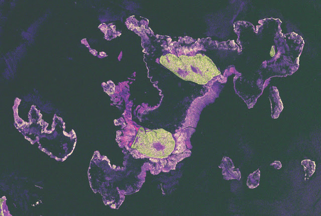
☝ The sensor explores the submerged sites with great precision. The boundary wall composed of stones, are here in shades separating the clear dark water bodies. Clear three fort wall structures are shown filled with green vegetation. The top human made fort structure appears as "cow-eye". the second one is the conch shaped fort structure and the third one is pitcher ( Kumbh ) shape fort structure fixed with lion head on top of the pitcher shape fort. The ceramic stone plates are in light white violet color . Human made stone structures are captured in white color. The vegetation parts are shown with green colors.
☝ The "Analogue Technology" is now used in understanding the sensor data. The white - violet shade is here "Great White Marble Palace" identified as the Raajmahal of Bhagwan Krishna.
☝ The sensor now explores a submerged fort, which fort wall moves in horse shape. The fort wall is in light shade, segregated from the deep ocean water showing in dark color. Inside the horse structure, bright white target area is seen , showing the human settlement.
☝ The "Analogue Technology" now explores the sensor detected submerged structure. This is a clear human made structure, where fort wall is designed and shaped in horse. Even horse belt is also exhibited in stone.
☝ The "Analogue Technology" now explores the inside of the horse fort area, at one area, where large human settlement is seen in straight rows.
☝ The "Analogue Technology" at the other area, now explores the inside of the horse fort area, at one area. This is filled with large human settlement seen in straight rows again.
☝ The sensor detects here huge submerged site of importance with human made structures, showing houses constructed in great detail, surrounded with boundary wall- upside and downside both. These houses in "Analogue Technology" is showing human settlement built in straight rows with clear boundary wall as shown in next image.
🌳🌳
See English presentation on the Dwarka Discovery on You-Tube. Click the link 👇
"Discovery of Dwarka" by Birendra K Jha
See Hindi presentation on the Dwarka Discovery on You-Tube. Click the link 👇


Comments
Post a Comment